


Mad Mutt Marine GPS Navigator

Mad Mutt Marine GPS Navigator의 설명
I started writing this application as something that would be useful to me. Since that it has grown and I am rather pleased with it. It is an aid to marine navigation and must be used in conjunction with charts that are printed on that white stuff that is called (So I’m told) paper.
Features
•Designed by and for a sailor. You may find that some of the layouts look “big and blobby” at first sight, but they work at sea. Fiddly and fussy layouts do not.
•No network required. This app uses your phone’s GPS, it will work where there is no mobile network coverage (though you will need network coverage to share your logs and waypoints by email).
•Store unlimited waypoints (restricted in free version).
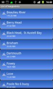
•View waypoints alphabetically of by distance from your current position.
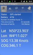
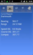
•Display range and bearing to a waypoint.
•Make logs of where you have been, which you can annotate with comments and other relevant data.
•View logs as display on the phone.
•Share logs with Google Earth on your phone or desktop computer, either by email or by copying KML files.
•Share waypoints with Google Earth on your phone or desktop computer, either by email or by copying KML files.
•Share logs with Google Earth on your phone or desktop computer, either by email or by copying KML files. Although I don’t encourage the use of Google Earth for marine navigation, seeing your waypoints on Google Earth is a useful visual check that you have transcribed them correctly.
•Anchor watch alarm service. Alerts you if you have moved more than a pre-defined distance. The anchor watch also alerts you if the battery level is low.
•Near waypoint alarm service
•Once started, the log, anchor and waypoint alarm services will continue to run, even if you quit the main navigator application. They will continue to run while you make phone calls or use your phone for email, Internet browsing or pretty much anything else.
What this application is not
It is not a chart plotter. This application is intended for marine navigation. Although it could be used by ramblers, that isn’t the main intention. It does not display digitised charts, nor does it show you a Google Map view with your position displayed on it. I believe it is highly irresponsible to encourage the use of Google maps to navigate boats. Even in rivers and estuaries, Google maps contain no semantics for the sea whatsoever; no lights and marks, depths, rocks etc. The application does allow you to send logs you have made to Google Maps, though, but only after you have completed the trip.
Free Version
For a limited time, a free version is available. In the Autumn of 2012 a full feature version should be available.
The free version has the following limitations:
•The number of waypoints you can have is restricted to 20.
•Routes are not available나는 나에게 유용 할 것 뭔가로이 응용 프로그램을 작성하는 시작했다. 그것은 성장했습니다 그리고 난 오히려 그것으로 기쁘게 생각합니다 그 이후. 이 해양 탐색에 대한 지원이며, (그래서 내가 말한 건) 종이라고 그 하얀 거에 인쇄되어 차트와 함께 사용되어야합니다.
특징
• 의해 선원에 대한 설계. 당신은 레이아웃의 일부가 첫눈에 "크고 blobby"봐,하지만 바다에서 일이 될 수 있습니다. 가로장 설치 등등과 칭얼 레이아웃하지 않습니다.
• 어떤 네트워크 필요하지 않습니다. 더 모바일 네트워크 범위가 (이 이메일로 로그 및 중간 점을 공유 할 네트워크 범위가 필요합니다하지만)이없는 곳이 앱이 휴대 전화의 GPS를 사용하여, 그것은 작동합니다.
• 스토어 무제한의 중간 점 (무료 버전 제한).
• 현재 위치에서 거리에 따라 알파벳 순의 중간 점을 볼 수 있습니다.
• 중간 점에 범위와 베어링을 표시합니다.
• 당신이 의견과 기타 관련 데이터와 주석을 수 있습니다 어디 있었어요의 로그를 확인하십시오.
• 전화 디스플레이로 로그를 볼 수 있습니다.
휴대 전화 나 데스크톱 컴퓨터에서 Google 어스 • 공유 로그, 중 이메일이나 KML 파일을 복사하여.
휴대 전화 나 데스크톱 컴퓨터에서 Google 어스 • 공유 경유지, 중 이메일이나 KML 파일을 복사하여.
휴대 전화 나 데스크톱 컴퓨터에서 Google 어스 • 공유 로그, 중 이메일이나 KML 파일을 복사하여. 나는 Google 어스에서 중간 점을보고, 해양 탐색을위한 Google 어스의 사용을 권장하지 않습니다하지만 당신은 정확하게 베꼈 한 유용한 시각 검사합니다.
• 앵커 시계 알람 서비스를 제공합니다. 당신이 사전 정의 된 거리보다 더 이동 한 경우를 알려줍니다. 배터리 레벨이 낮 으면 앵커 시계도 알려줍니다.
• 주변 좌표 알람 서비스
당신이 주요 탐색기 응용 프로그램을 종료하는 경우에도 • 일단 시작 로그 앵커와 좌표 알람 서비스는 계속 실행됩니다. 당신이 전화를 걸거나 이메일, 인터넷 검색이나 다른 거의 아무 휴대 전화를 사용하는 동안 그들은 계속 실행됩니다.
이 응용 프로그램은 아니 지요
이 차트 플로터 없습니다. 이 응용 프로그램은 해양 탐색하기위한 것입니다. 이 ramblers에 의해 사용될 수 있지만, 그 주요 의도하지 않습니다. 그것은 디지털 차트를 표시하지 않으며, 당신에게 위치가 표시가있는 Google지도보기를 표시 않습니다. 나는 배를 이동하려면 Google지도의 사용을 장려하기 위해 매우 무책임한하다고 생각합니다. 심지어 강 하구에서 Google지도는 무엇이든지 바다에 대한 의미가 포함은 없어 빛과 마크, 깊이, 암석을 등 응용 프로그램은 당신이하지만, Google지도에 한하지만를 완료 한 후에 만 로그를 보낼 수 있습니까 여행.
무료 버전
제한된시기 동안, 고객의 무료 버전을 사용할 수 있습니다. 2012 년 가을에는 전체 기능 버전을 사용할 수 있어야합니다.
무료 버전은 다음과 같은 제한이 있습니다 :
• 당신이 할 수 중간 지점의 수는 20로 제한됩니다.
• 경로를 사용할 수 없습니다
Mad Mutt Marine GPS Navigator - 버전 1.07
(04-08-2014)
Mad Mutt Marine GPS Navigator - APK 정보
APK 버전: 1.07패키지: uk.ac.plymouth.madmutt.gpsnavigatorMad Mutt Marine GPS Navigator의 최신 버전
다른 버전들


동일 카테고리의 앱


